Although natural disasters such as earthquakes and volcanic eruptions have accompanied us humans throughout our entire history, we have been steadily striding to the ultimate goal where our response, coupled with knowledge and technology, can greatly mitigate or outright prevent major tragedies from happening. From geophysical predictions and telecommunications to damage-surveying drones, we are undoubtedly more prepared than ever to respond to large-scale natural threats anywhere.
Or at least we should be, right?
The reality is that the necessary research frameworks and technology for disaster prediction and mitigation are not as widely deployed in developing countries as in first-world countries. For example, even though Japan is hit by earthquakes and tsunamis just like many ASEAN countries, the latter are more vulnerable due to economic differences.
That's why Professor Hiroshi Inoue, who originally majored in Earth Sciences, has dedicated much of his career to seismology and natural disaster prevention and mitigation in the ASEAN region. Through earthquake and volcanic observations, as well as innovative developments and creative usage of available technology, Prof. Inoue has contributed much to improving the ways in which we can assess the risks of natural disasters and react to them.
Image provided by Prof. Hiroshi Inoue
A long track record in the field
Out of a fascination for the forces of nature and a fondness for mountain climbing, Prof. Inoue began his journey down his research path by joining the Seismology Laboratory in the Department of Earth Sciences at Nagoya University. His first job, which he maintained for eight years, was at IISEE, the Building Research Institute, which conducts one of Japan International Cooperation Agency (JICA)'s group training courses for teaching seismology and earthquake engineering to people in developing countries.
His first time working at a foreign country was when he helped in the construction of an earthquake observation network in Egypt as a JICA Technical Cooperation Project. This experience naturally led to earthquake observation and data gathering projects in the Asia-Pacific region, which soon grew to be the area in which he'd be most involved.
Prof. Inoue cites many different reasons for why he decided to focus on ASEAN countries. "The Asia-Pacific region is very prone to disasters, even from a global perspective. This is partly because of the many earthquakes and volcanic eruptions that occur as natural phenomena and partly because these countries are more vulnerable to disasters, even though the same phenomena also occur elsewhere. Thus, I felt I wanted to contribute to our neighbors and this region as much as possible," he explains. In addition, he remarks that, from Japan, countries such as Philippines and Indonesia are just around the corner, so it is easier to be actively researching there thanks to cheap airfares and a manageable time difference of less than four hours.
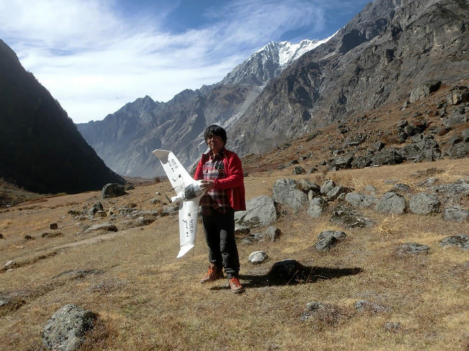
Image provided by Prof. Hiroshi Inoue
Observing and predicting earthquakes
Prof. Inoue remarks that earthquakes are incredibly difficult to predict, at least within a timeframe that can be useful to us. This is because earthquakes happen when a solid rock cracks under the gradual accumulation of forces. Unlike volcanic or weather events, which are caused by more easily observable fluids, there are no known ways of precisely telling when and where a damaging earthquake will take place.
While a technology for accurately predicting earthquakes would be a sort of holy grail for seismologists, Prof. Inoue thinks that the focus should not be put exclusively on such difficult, very long-term goals. "In terms of baseball, if we only aim for a home run, we will keep striking out and won't be able to score any points," he explains.
Thus, Prof. Inoue believes it is important to keep making steady progress in areas where we can already make predictions, such as early tsunami and earthquake warnings, which are issued after an earthquake occurs; volcano eruption predictions which almost always have precursors, and weather-related disasters as well.
"People's preparedness is most important to reduce disasters," he remarks. "Natural phenomena themselves do not cause disasters. Disasters occur because people are unaware of what will happen. Disasters repeat when people forget past tragedies."
Eyes in the sky - Satellites and custom drones for damage assessment and topography
Part of Prof. Inoue's research has involved the use of satellites to observe and gather data related to volcanic activity and earthquakes. This method is referred to as 'satellite telemetry.' Satellites are useful for both telemetry and communication in general, because they have certain advantages over ground lines or ground-based forms of wireless communication. This is because satellites are mostly unaffected by natural disasters and can be used in extremely remote areas. "With telephone lines, ordinary optical fiber, and other terrestrial lines, you can only install them where the line is connected, but with satellites, you can install them anywhere because they are more flexible," comments Prof. Inoue.
As part of Japan's SATREPS (Science and Technology Research Partnership for Sustainable Development), Prof. Inoue's involvement in the Philippines project was the utilization of a small-scale satellite communication system provided by a telecommunications company. This was based on a previous system developed by JICA, which was the first modern seismic and volcanic observation system deployed in the Philippines.
Around the time of the 2009 earthquake in Indonesia, Prof. Inoue also saw the potential of drones and similar unmanned aerial vehicles as tools for surveying the damage caused to buildings by natural disasters. Taking pictures of buildings damaged by an earthquake, for example, can be used to determine if there is any immediate risk of collapse, or if people are trapped in inaccessible locations.
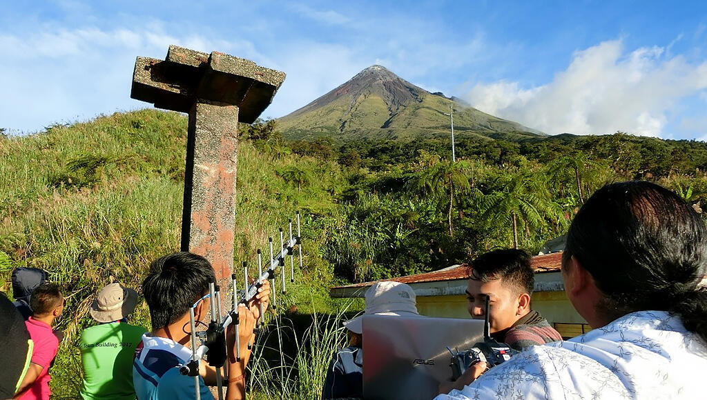
Image provided by Prof. Hiroshi Inoue
When the 2011 Great East Japan Earthquake happened, Prof. Inoue thought it would be helpful to take aerial photographs to clearly record the damage. "At that time, we didn't really have a drone that could be used for our practical purposes, so we asked an expert who flew radio-controlled helicopters to attach a small camera, the original GoPro, to our radio-controlled helicopter. We had it fly over the disaster area to take pictures, and that marked the first time we recorded a disaster area using something that could fly in the sky," recalls Prof. Inoue.
Research using drones flourished in subsequent years as drone technology steadily evolved and added attractive features, improved autonomy, and better stabilization. Prof. Inoue and his colleagues later developed a homemade drone that could fly in autopilot while taking aerial pictures in a neat grid pattern. Afterwards, along with researchers in the Philippines, Thailand, Vietnam, and Indonesia, Prof. Inoue and his colleagues worked on an airplane-type drone that could fly farther and over a greater area. "Airplane-type drones that can fly tens of kilometers already existed and could be bought if you had the money," explains Prof. Inoue, "However, such drones cost millions of yen each, and developing countries can't afford them. The models we've worked on can be built for about 100,000 yen, and can fly more than 100 kilometers. I've been actively working on building systems that fit the actual conditions of each country and then establishing methods for operating them."
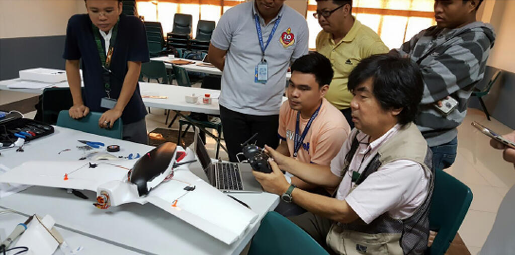
Image provided by Prof. Hiroshi Inoue
Geographic Information Systems (GIS) and the importance of integration
The amount of information that can be gathered from the ground is completely different from what can be seen from the sky, and Prof. Inoue is an avid advocate of the use of drones. However, it's essential to develop systems that can take the gathered aerial data and put them on a common map so that everyone can benefit from it. This is especially important in times of disaster, as Prof. Inoue explains: "Just by taking an aerial picture, you can see what the situation is like at the location, but the people who are there cannot. In order to cope with emergency situations, these data have to be quickly put on a map to see the whole picture on a common platform."
Another use of GIS is to gather data to develop hazard maps and vulnerability maps, which can be used to easily calculate the risks for individual buildings by combining them with maps of building distributions. Such tools can help guide decision makers to invest in risk reduction strategies in more efficient ways.
The road ahead
Prof. Inoue stresses that, to address current challenges, young students and researchers will have to adapt to new technologies and come up with creative ways to use them for their purposes. One clear example is artificial intelligence (or AI), which could be useful for making more accurate predictions for both 'soft' phenomena (volcanic activity and weather) and 'hard' phenomena (earthquakes).
"Various new technologies will emerge and continue to be developed in the future, so I would like young researchers to keep a watchful eye on them, because you can always see things that have not been seen before by using the latest tools, whether in a personal search for truth or in scientific research," Prof. Inoue concludes.
Although he is currently retired, Prof. Inoue is still working as a visiting researcher at NIED, National Research Institute for Earth Science and Disaster Resilience, and gives lectures and is a visiting researcher at IISEE, The Building Research Institute. He is currently working on four projects at Chubu University, the Disaster Prevention Research Institute of Kyoto University, and the Building Research Institute, and hopes that the results of all the research he is doing in Japan can be taken to other parts of the world and put to good use.
Let us hope further international research efforts pave the way to a better future for us all, in which natural disasters can be better managed or outright prevented no matter the country in which they happen.
Produced by the Science Japan Editorial Team.