
A research group led by Professor Yoshihiro Tachibana of the Graduate School of Bioresources, Mie University, through analysis and numerical simulations of observed values conducted over the past 39 years, have discovered that the formation of large rain clouds in the Sahel region of Africa triggers high pressure over Japan, resulting in jet stream meandering.
The Sahel region is located south of the Sahara Desert and is characterized by a savannah climate with distinct rainy and dry seasons. The causes of the increases and decreases in rainfall in this region have been mainly investigated by European researchers to date. In Japan, studies regarding extreme weather patterns have been actively conducted to consider the effects of climatic conditions, such as El Nino, in tropical oceans. However, the effects of rain clouds on tropical land far from Japan, such as the Sahel region, have not been explored. The group conducted research from this as of yet explored perspective to clarify the mechanisms of abnormal weather in Japan and Asia.
In the Sahel region, there is heavy rain during its distinct rainy season (June-September). During this period, rain clouds form and cover the sky in the Sahel region. These widespread clouds increase the pressure over northern Africa. This high pressure leads to meandering of the westerlies that blow over Europe, continuing in East Asia and Japan, which are located downstream of the westerlies. This 'jet meander' increases the high pressure over Japan, and so has a knock on an effect on the weather in Japan.
From this, it can be concluded that the more rain clouds form in the Sahel region, the higher the pressure over Japan, leading to extreme heat in the country. In fact, when Japan recorded the strongest heat wave in history in 2018, heavy rainfall was also observed in the Sahel region. High pressure causes the atmosphere to become compressed, leading to a rise in temperature. The clouds dissipate and intense sunlight hits the ground. Professor Tachibana said, "The atmosphere at the time of the landslides in Atami City on July 3 is similar to the research results presented here. There is also intense precipitation in Sahel this year. Due to this link, I would like to speed up the analysis of the relationship between the weather this year and the Sahel region. Since the Arctic amplification also affects the meandering of westerlies, the effect of Sahel on the westerlies may become more pronounced in the future. Therefore, I would like to further my research with a focus on the effects of both the Sahel and the Arctic. "
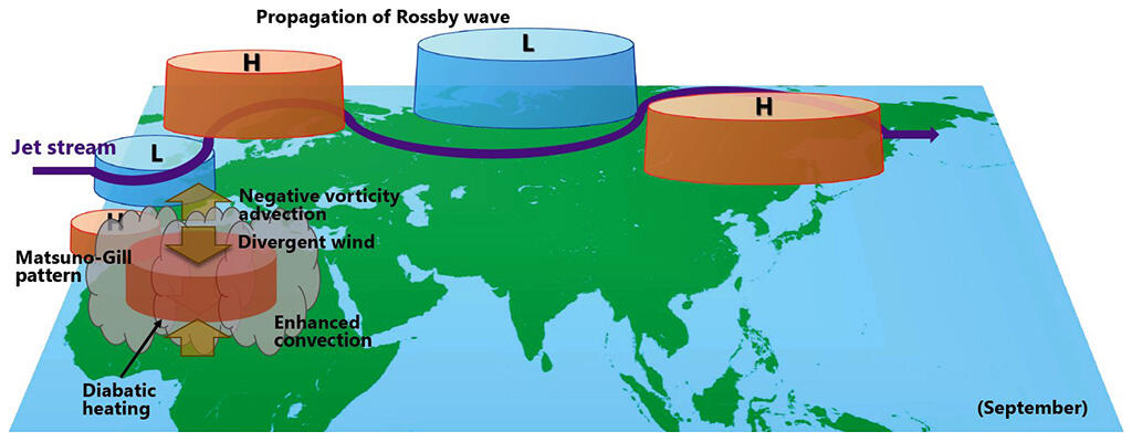
1) Enhanced deep convective clouds on over the Sahel
2) Anomalous heat source due to the deep convection strengthens high pressure over North Africa
3) Meandering of the mid-latitude jet stream over Europe
4) The jet meander in turn propagates eastward across Eurasia as far as East Asia.
5) High pressure over East Asia
6) Anomalously hot over East Asia
Credit: Yoshihiro Tachibana, Mie University
This article has been translated by JST with permission from The Science News Ltd.(https://sci-news.co.jp/). Unauthorized reproduction of the article and photographs is prohibited.