
For the first time, a research group, composed of Tohoku University and Hokkaido University, demonstrated that the GNSS (Global Navigation Satellite System) observation network (over 3,300 points nationwide) operated by SoftBank can grasp the state of crustal deformation with unprecedented high spatial resolution and sufficient accuracy. In the future, it is expected to greatly contribute to disaster prevention and mitigation, for example, capturing the epicenter image of a large earthquake and long-term evaluation of the occurrence of an earthquake on an inland active fault. These results were published online in Earth, Planets and Space journal.
Provided by Tohoku University
Knowledge of crustal deformations associated with earthquakes and volcanic activity with high accuracy is very important not only for understanding the phenomena but also for predicting their occurrences. In Japan, crustal deformation monitoring has been undertaken with high accuracy using the GNSS observation network (electronic reference point: GEONET, over 1300 points nationwide) operated by the Geospatial Information Authority of Japan (GSI). However, From November 2019, SoftBank started the operation of its own original GNSS observation network (SoftBank's own reference point) with more than 3300 points nationwide for the purpose of improving the positioning service. However, no verification of the accuracy of the network for use in earth science applications, such as crustal deformations, had been conducted to date.
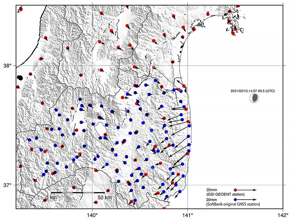
The research group was provided GNSS observation data from SoftBank's own reference stations and analyzed it to verify the accuracy of the crustal deformation field by the observation network. The evaluation was conducted on data from two crustal deformation fields: a deformation field which was seismically quiet (Miyagi Prefecture, for September 2020-March 2021) and a crustal deformation field where an earthquake occurred (February 13, 2021, Earthquake of the coast of Fukushima (M7.3)). Looking at the horizontal and vertical deformation fields from September 2020 to March 2021, SoftBank's original GNSS stations and the GSI's electronic reference points showed variations in the data. Looking at the horizontal and vertical deformation fields during the earthquake following the February 13, 2021 earthquake off the coast of Fukushima (M7.3), horizontal movements of about 2 cm in the west-southwest centered on the coast of Fukushima Prefecture were confirmed, and it became clear that SoftBank's original GNSS station can accurately capture not only long-term crustal deformations but also displacements during earthquakes.
These results are important, and they showed that the observation network can contribute to the advancement of long-term evaluation of earthquake occurrence by grasping the epicenter image of large earthquakes and estimating the strain accumulation in inland active faults. It is expected to greatly contribute to disaster prevention and mitigation as an important infrastructure that complements the electronic reference points of the GSI. Furthermore, GNSS is being used not only in crustal deformations but also in a wide range of earth science fields, for example, grasping the amount of water vapor in the troposphere. It is expected that SoftBank's original GNSS stations will have a great impact on those fields.
This article has been translated by JST with permission from The Science News Ltd.(https://sci-news.co.jp/). Unauthorized reproduction of the article and photographs is prohibited.