
Linear precipitation zones are a phenomenon attracting attention in recent years for their potential to cause large-scale flooding. A research group including the National Research Institute for Earth Science and Disaster Prevention (NIED) studying linear precipitation zones is strengthening the monitoring framework using the water vapor observation network in Kyushu to carry out an experiment aiming to achieve greater forecast accuracy in time for early June when linear precipitation zones typically occur in western Japan, in collaboration with 11 local governments in Kyushu.
Courtesy of NIED
According to a study by the Meteorological Research Institute (MRI) of the Japan Meteorological Agency (Tsuguchi and Kato: 2014), more than 60% of torrential rains, excluding those directly caused by typhoons, are caused by linear precipitation zones.
However, in order to accurately predict the occurrence of linear precipitation zones, greater forecast accuracy is required by accurately forecasting each individual cumulonimbus cloud in the zone. One important factor in predicting cumulonimbus clouds is knowing the amount of water vapor at low altitudes of below one kilometer, the source of rainfall. The group expects that by observing the amount of water vapor present before cumulonimbus clouds begin to form, it will be possible to predict the formation of those clouds, which would lead to a significant increase in the accuracy of forecasting linear precipitation zones.
Given that research on forecasting linear precipitation zones is extremely important from the standpoint of disaster mitigation, the research group, consisting of NIED along with the National Institute of Information and Communications Technology (NICT), Nagoya University, Fukuoka University, Nippon Antenna, and MRI, was among the first to work on this project under the Cross-ministerial Strategic Innovation Promotion Program (SIP) of the Cabinet Office.
As part of the SIP, the group has been working on a project to develop a new system for the observation and forecasting of linear precipitation zones since 2018 in the category of Strengthening National Resilience (disaster prevention, mitigation).
To date, NIED has taken the lead in the observation and forecasting of cumulonimbus clouds. Meanwhile NICT and Nippon Antenna have worked on the observation of water vapor volume using the terrestrial digital broadcast band, while Fukuoka University has worked with MRI on water vapor lidar observation, NIED has worked on ground-based microwave radiometer observations, and Nagoya University has been developing technology for airborne observations.
The group is working to develop technology allowing more accurate forecasting of linear precipitation zones up to two hours beforehand by leveraging the latest water vapor observational data, and they are currently working out forecast accuracy and how to use forecasting data through the experiment being run in collaboration with eleven local governments in Kyushu.
Through this focused observation of the linear precipitation zones phenomenon, MRI is taking a central role in the observation of water vapor over land. The group began airborne observation in order to monitor water vapor volume over the ocean in order to strengthen monitoring from July. The observational data will be shared with universities and research institutes throughout the country and used in order to study the mechanism by which linear precipitation zones occurs.
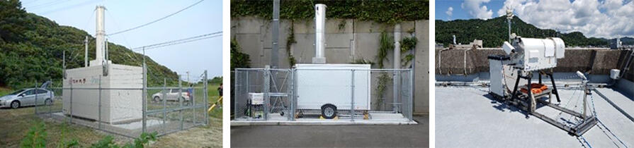
Regarding the observation network, Fukuoka University installed a water vapor lidar at Nomozaki, Nagasaki, Nagasaki Prefecture and Shimokoshiki-jima in Satsumasendai, Kagoshima Prefecture, and subsequently began observations in June and August 2020 respectively. NIED then installed a doppler lidar in the same Shimokoshiki-jima facility in 2021 to evaluate the inflow of water vapor.
Meanwhile, ground-based microwave radiometers capable of measuring the total amount of water vapor in the sky were installed on Fukue Island, Nagasaki Prefecture, in October 2020 and in Amakusa, Kumamoto Prefecture, in May 2021 before beginning observations. Furthermore, two of the water vapor observational devices jointly developed by NICT and Nippon Antenna using the terrestrial digital broadcast band were installed in northern Kumamoto Prefecture in 2020, while additional devices were installed in Oita, Fukuoka, and Saga prefectures, and plans are to develop a network of a total of 15 units with 10 more installed south of Kumamoto by March 2022.
This is a low-cost observational method that leverages the terrestrial broadcast signals available for use anywhere in the country. The method, developed by NICT, uses the phenomenon by which the transmission speed of terrestrial broadcast signals changes when passing through areas where water vapor is increasing, allowing for the observation of water vapor volume.
The group is currently working towards the practical application of the method, and a test operation is being carried out in the Kyushu area for the commercialization of a data transmission cloud service by Nippon Antenna.
This article has been translated by JST with permission from The Science News Ltd.(https://sci-news.co.jp/). Unauthorized reproduction of the article and photographs is prohibited.