
A research group consisting of Principal Researcher Yoshihiko Tamura of the Volcanos and Earth's Interior Research Center (VERC), Research Institute for Marine Geodynamics, Japan Agency for Marine-Earth Science and Technology (JAMSTEC), and members of Niigata University has proposed a new model for the origins of the Mohorovicic Discontinuity (the Moho), the boundary between the Earth's crust and the mantle, and the oceanic crust.
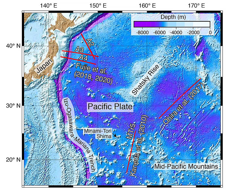
Solid red lines show seismic reflection and refraction profiles conducted by JAMSTEC and Japan Coast Guard in the northwestern Pacific Ocean, which were examined in this study. The seismic reflection and refraction survey line by Ohira et al. (2017) was approximately 1,130 km long, which is one of the longest single seismic profiles in the northwestern Pacific, and it spans old Pacific Plate ranging from 148 Ma, at the southwestern end, to 128 Ma at the northeastern end. Strong and continuous Moho reflections were only observed at the southwestern end of the profile (for about 50 km), whereas Moho reflections were diffuse, weak, or absent along the rest of the profile (about 1,080 km). The survey line (MTr5) by Kaneda et al. (2010) crossed two large seamounts, Batiza and Tayama guyots in the Marcus-Wake seamount chain, and also includes Jurassic oceanic seafloor in the northern basin (about 159 Ma), at the northern end, and in the southern basin (about 167 Ma), at the southern end. These two basins have significantly different Moho reflections and crustal thickness. A2, A3, and A4 are seismic survey lines studied by Fujie et al. (2018, 2020). This part of the Pacific Plate was formed at 130-140 Ma at a fast-spreading ridge. The appearance of the Moho reflections and crustal thickness are variable in the region 200-400 km along the profile.
Provided by JAMSTEC
In the past, there was wide support for the Penrose Model, which suggests that the crust and the mantle differ in substance and so the boundary (the Moho) between them is clear, but after investigating the Northwest Pacific Ocean region, researchers have learned that, unexpectedly, the boundary is unclear in over 90% of locations. From this background, the research group explored the reality and origins of the Moho. They based this on research outcomes connected to seismic wave propagation at the Moho, obtained via past seismic reflection and refraction surveys covering a total distance of over 3,000 km on the seabed of the Northwest Pacific Ocean, and on petrographic research on the boundary between the crust and the mantle at the ophiolite (rock in which the sequential strata from the oceanic crust to the upper mantle can be seen) in the Sultanate of Oman.
Their results led to the creation of a new origin model showing the relationship between the oceanic crust and the Moho: if there is an influx of seawater at a mid-ocean ridge that forms the oceanic crust, more magma is generated and the crust becomes thicker, so the boundary is clearer, whereas if there is no influx of seawater, the boundary is unclear. This model is groundbreaking in terms of its approach to the reality of the oceanic crust, the lithosphere that stretches around the largest area of the surface of the Earth, and the Moho, unreached by humans. From here, to understand the internal structure of the Earth, further investigation and verification are needed.
This research has seen the group investigate the oceanic crust using seismic waves and focus on the crust-mantle boundary known as an ophiolite, which is exposed on land, to submit this new model. During this process, they found that an entirely new phenomenon was needed to form the Moho: an influx of seawater to the mantle at a mid-ocean ridge. However, this phenomenon rarely occurs, and so there is no Moho in the majority of oceanic areas.
Principal Researcher Tamura commented, "If a seawater influx event has taken place, we expect andesite, rather than basalt, to upwell at a mid-oceanic ridge. We hope to verify whether this model is correct by collecting rock from the seabed in places where the Moho covers a wide area, and places where there is no Moho."
■ Seismic reflection survey: A survey method that observes reflected waves (echoes) from sound waves generated at the ocean surface that have reverberated underground and returned to the surface, and gains an understanding of the depth of the reflecting surface based on the time the waves take to rebound (known as the return time).
■ Refraction survey: A refraction (structure) survey that uses OBS (measuring equipment that carries out seismic observation on the seabed from within pressure-resistant containers. E.g. seismometer, battery) and which is an observation method that grasps deep seismic velocity structure by oscillating sound waves from the ocean surface to OBS positioned on the seabed in advance, and receiving the waves returning to the seabed after they have passed deep underground.
This article has been translated by JST with permission from The Science News Ltd.(https://sci-news.co.jp/). Unauthorized reproduction of the article and photographs is prohibited.