
A research group consisting of Assistant Professor Yusuke Yamashita of the Miyazaki Observatory, Disaster Prevention Research Institute (DPRI), Kyoto University; Senior Researcher Kei Ioki of the National Institute of Advanced Industrial Science and Technology (AIST); and Yoshihiro Kase of the Hokkaido Research Organization (HRO) has created a new fault model for the 1662 Hyuga-Nada earthquake, thought to be the largest ever in the Hyuga-nada region in eastern Kyushu, based on recent geophysical knowledge, including outcomes from seismic observations of shallow slow earthquakes on the sea floor. The group evaluated their new fault model through the results of surveys of tsunami deposits along the coast of Miyazaki Prefecture and a tsunami inundation simulation that made use of the fault model. Through this, they scientifically demonstrated that this could have been a massive earthquake of M (magnitude) 7.9, which had never been done before. This is attracting attention as a new perspective that overturns the prevailing view that earthquakes of M8 level do not occur in Hyuga-nada, suggesting the possibility of such an occurrence. It may be necessary to use this for earthquake and tsunami measures in the region in the future.
Provided by the Disaster Prevention Research Institute, Kyoto University
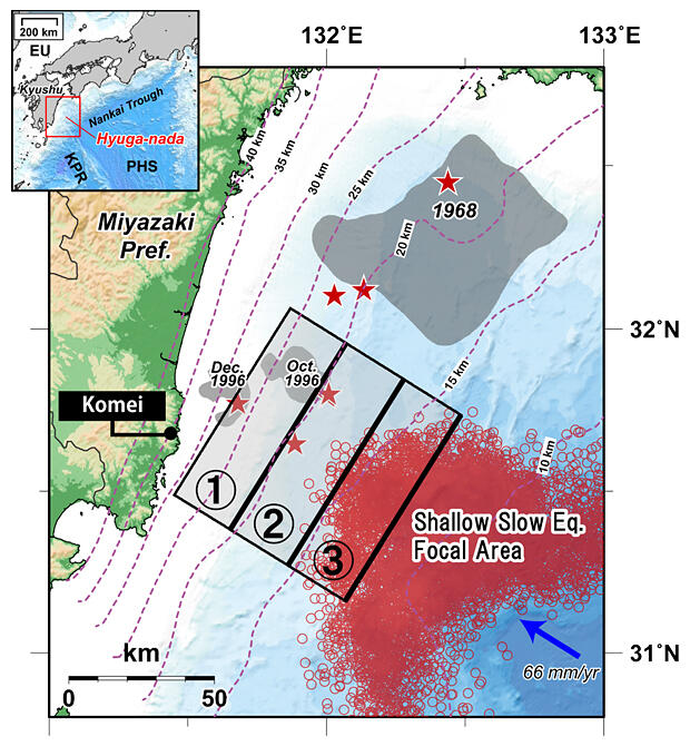
Trench earthquakes of M7 level occur at intervals of a few decades in Hyuga-nada. Based on past research, the scale of the 1662 Hyuga-nada earthquake (known locally as the Tontokoro Earthquake) was estimated at M7.6, and it is thought to have been the largest earthquake in the area. It was also characterized by 'strong tremors' and a 'great tsunami', which have not been experienced in any earthquakes in Hyuga-nada in the past 100 years.
However, several fault models that have been advocated in the past have been unable to explain both the tremors and the tsunami, so the details of the event were unclear. Moreover, the estimate of M7.6 is not a modern observation from a seismograph — it's from descriptions of the damage in historical documents, so Yamashita and his colleagues felt that without an explanation for the calculations, the scientific basis for this was rather weak.
The 2011 Tohoku Earthquake was characterized by 'strong tremors' and 'a great tsunami', and the involvement of the slow earthquakes that occur in the shallow parts of the plate boundary was identified as one of the causes of the growth of the quake to M9. Assistant Professor Yamashita focused on this.
The group built up a hypothesis: 'Perhaps the source area of the shallow slow earthquakes was the origin of the wave of the great tsunami in the 1662 Hyuga-nada earthquake?' To verify this, they created a new fault model based on the latest knowledge, and revaluated this earthquake via an inundation simulation carried out using this model and via a survey of tsunami deposits in the local area.
The new fault model was constructed with reference to the damage according to historical documents, using the latest geophysical knowledge in Hyuga-nada, such as shallow slow earthquake activity learned from seismic observations on the seabed, information on the depth of the plate boundary obtained from artificial seismic waves, and the position of sunken seamounts estimated from magnetic abnormality maps.
The new model is made up of three faults: the deepest fault 1, which caused the strong tremors that characterized the earthquake, the shallow extensional fault 2 and the fault 3 that was the hypocenter of the shallow slow earthquake connected to the great tsunami. Faults 1 and 2 lie in deep areas of more than 15 km and have caused M7-level plate boundary earthquakes over the past 100 years; these cause strong seismic motion due to their proximity to the land. Fault 3 is normally the hypocenter of shallow slow earthquakes, but when the great earthquake occurred the fault slipped quickly, and the slip was set to be several times larger than faults 1 and 2.
The group compared tsunami heights obtained from the simulation with the previously reported tsunami height on the coast, and explored fault length and fault slip through trial and error to minimize the gap; consequently, they found a fault length of around 80 km and slips of 2 m, 4 m and 8 m for faults 1, 2 and 3 respectively.
To investigate how far the tsunami reached on land, they surveyed the presence of tsunami deposits in the lowlands along the coast of Miyazaki Prefecture and found tsunami deposits formed from the tsunami of the 1662 Hyuga-nada earthquake in Komei, Nichinan City.
Then, they carried out a tsunami inundation simulation to see whether their newly constructed fault model could explain these tsunami deposits. It did show that the tsunami caused by the earthquake brought about inundation up to the location where the tsunami deposits were discovered, and so could largely explain the survey results.
Part of their research outcomes have already been reflected in "Hyuga-nada oyobi Nanseishoto Kaiko Shuhen no Jishin Katsudo Choki Hyoka (version 2) [Long-term evaluation of earthquake activity in Hyuga-nada and the area of the Nansei Islands Trench]", published by the Japanese Headquarters for Earthquake Research Promotion in March 2022. However, the construction of this new fault model is still lacking - as the tsunami inundation simulation was only implemented for one area (Komei, Nichinan City), Yamashita and his colleagues will continue their investigations and research so they can clarify the whole story of this earthquake.
It is also necessary for them to hurry this investigative research in preparation for the next M8-level massive earthquake. As their current research system with few people likely won't be able to complete the required investigations, they are requesting to create a survey system with collaboration from local governments and people.
Journal Information
Publication: Pure and Applied Geophysics
Title: Effects of the tsunami generated by the 1662 Hyuga-nada earthquake off Miyazaki Prefecture, Japan
DOI: 10.1007/s00024-022-03198-3
This article has been translated by JST with permission from The Science News Ltd. (https://sci-news.co.jp/). Unauthorized reproduction of the article and photographs is prohibited.