
The Remote Sensing Technology Center of Japan (RESTEC) and Spectee Inc. disclosed the results of their verification system that uses spatial IDs to control and display flooding information three-dimensionally during a disaster. Such information acquired from satellites and Social Networking Services (SNSs) were among the subjects in a research project related to digital twin construction by the Digital Agency.
In recent years, meteorological disasters have been causing severe damage in various regions. Under such circumstances, floods and other disasters have been recurring. As countermeasures, municipal governments and administrative bodies are prioritizing preparations that are based on advanced information management and aggregated historical information.
This study attempted to reproduce a flooding scenario in an urban area during a disaster. This was achieved by developing a system that combines flooding information from satellites and SNSs with topographical and infrastructural information to create three-dimensional (3D) displays of the collated information.
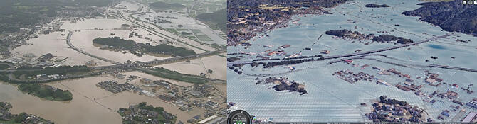
A 3D image that overlaps satellite and SNS data is displayed in Fig 1. The data were collected during the heavy rains in August 2019. The subject area encompassed municipalities in the Rokkaku-gawa basin in Saga Prefecture. The image bears a striking similarity with an actual photo of the inundation in the vicinity of the Takeo-Kitagata Interchange on Ariake Engan Road, which was published by the Ministry of Land, Infrastructure, Transport and Tourism after the torrential downpour (the image on the left; both images are courtesy of RESTEC and Spectee). Thus, the comparison can confirm the high quality of reproducibility and visibility of the damage.
Provided by the Remote Sensing Technology Center of Japan
Flooding information is managed, vectorized, and tiled by spatial ID as the unit of measure. By combining such information with information on buildings provided by Plateau (open data on 3D urban models of facilities from all over Japan) and then displaying a 3D image, the system can identify approximately how many centimeters each building has sunk. Cesium, an open-source platform for visualizing 3D geographical space, was used for visualization and Photorealistic 3D Tile, an imaging software, was used to provide a highly accurate, comprehensible display environment.
The system combines the broad coverage provided by satellite data, which stores information on inundation in a wide area, with the promptness provided by the information from SNSs. From this the system successfully and promptly generates accurate inundation data. The system further uses spatial IDs in addition to flooding information and creates a 3D visualization. In this way, users can understand and review the status of damage. This system will improve resident services by enhancing the efficiency of municipal governments, including a shorter lead time for issuing disaster certificates. Advanced digital twin technology can be adopted to expand the system's use, for example, to guide evacuees or to support life-saving efforts, which may require real-time high performance.
RESTEC and Spectee plan to expand the areas of use in cooperation with their stakeholders based on the knowledge and technology acquired through the current verification experiment.
This article has been translated by JST with permission from The Science News Ltd. (https://sci-news.co.jp/). Unauthorized reproduction of the article and photographs is prohibited.