
A research group led by Professor Yasufumi Iryu of the Graduate School of Science at Tohoku University, in collaboration with the National Institute of Advanced Industrial Science and Technology, the University of the Ryukyus, and Akita University, announced that they have proposed a new "OMSP hypothesis" to explain the process of biota formation on Miyako Island. By integrating geological and biological knowledge, they revealed that the Okinawa−Miyako submarine plateau (OMSP), located between Okinawa Island and Miyako Island, was a terrestrial area spanning up to 400 km approximately 5.5−0.27 million years ago (Ma). This area potentially served as a transit point of migration for biological movement from Okinawa Island to the Miyako Islands. This new knowledge is expected to lead to the clarification of the geological history of the Ryukyu Islands. The results were published in the July 20 issue of Progress in Earth and Planetary Science, an international journal published by the Japan Geoscience Union.
Provided by Tokohu University
The biota of the Ryukyu Islands is known for its diversity and uniqueness, but many uncertainties about its process of formation remain. The reason for the many uncertainties about how the Ryukyu Islands were formed is that they are located on plate boundaries and have undergone a complex formation process.
The present-day Miyako Islands are flat, with a maximum elevation of 110 m. They are predominantly covered by the Pleistocene Ryukyu Group that were composed chiefly of the carbonates formed in coral reefs and associated fore reefs to shelves. Based on the layering of the geological strata and the ages of fossils, the deposition of the Ryukyu Group on the Miyako Islands is estimated to have occurred between approximately 1.25 and 0.4 Ma. Prior to this period, the islands were repeatedly submerged owing to drastic fluctuations in ice sheet volumes caused by climatic changes.
Many endemic species inhabit Miyako Island, and even fossils of species that no longer exist today have been discovered. Although the Habu snake (Protobothrops flavoviridis) currently inhabits the central Ryukyu Islands, such as Okinawa, Tokuno, and Amami Oshima, only fossils of species that lived more than 20 thousand years ago have been found on Miyako Island.
For example, the Miyako keelback snake (Hebius concelarus, a snake of the Colubridae family), which is endemic to Miyako Island, has closely related species living on Okinawa Island and other areas. However, molecular phylogenetic analysis reveals that it diverged from other species during 3.7−1.8 Ma, when Miyako Island was submerged. It was difficult for these endemic species to cross the 360-km-wide sea between Okinawa Island and Miyako Island. Therefore, researchers believe that it differentiated as an endemic species in a location distant from Okinawa and subsequently expanded its distribution to Miyako circa 0.4 Ma, when this island became landlocked.
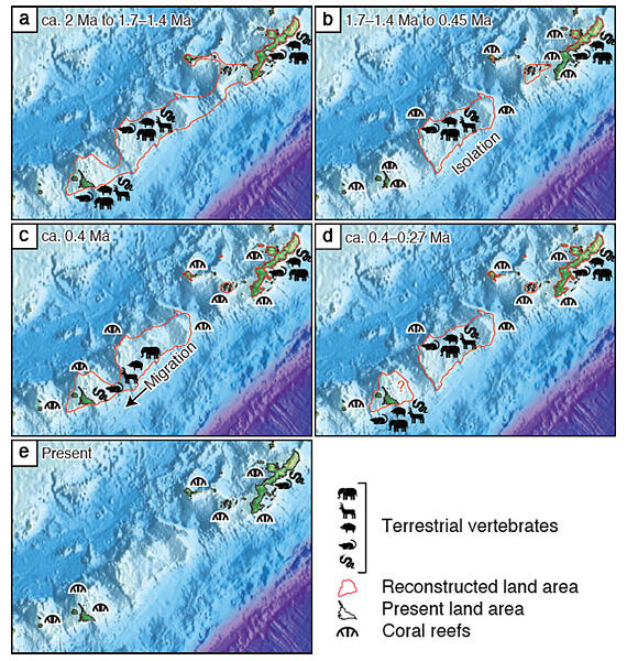
By integrating data from terrestrial geology, marine geology, structural geology, and biological geography, the research group proposed the OMSP hypothesis that satisfies these conditions. Two years ago, samples from drilling surveys that were carried out by Teikoku Oil Co., Ltd. and other companies in 1978 were re-analyzed with consent. As a result, it was discovered that the OMSP might have been a terrestrial area circa 5.5−0.27 Ma.
In the southern part of Okinawa Island, mudstone-dominated strata (Shimajiri Group) were deposited circa 8−2 Ma. These layers are distributed in the central axis of the island beneath the Ryukyu Group. Evidence suggests that the Shimajiri Group emerged as land and underwent erosion prior to the deposition of the Ryukyu Group. It is estimated that the Shimajiri Group was deposited at a water depth of several hundred meters, indicating that the southern part of Okinawa Island was rapidly uplifted circa 2 Ma.
Furthermore, the results of investigative voyages have revealed that the rapid uplift in the southern part of Okinawa Island was caused by the Kerama Gap (a right-lateral strike-slip fault that formed a depression separating Okinawa and the OMSP). This uplift not only affected the southern part of Okinawa Island but also extended to the Kerama Saddle (a ridge-like topography between Okinawa and the OMSP). This connected the OMSP with Okinawa Island circa 2 Ma, forming a massive island that stretched 400 km in a northeast-southwest direction. Researchers believe that during this process, the plants and animals of Okinawa Island spread their distribution to the OMSP.
Circa 1.7−1.4 Ma, coral reefs began to form in the Okinawa area, isolating it from the OMSP. Additionally, circa 1.25 Ma, the Miyako Islands were repeatedly submerged. During this period, the OMSP existed as a separate terrestrial area isolated from both Okinawa Island and Miyako Island. The uplifting of Okinawa Island began circa 0.45 Ma, while that of the Miyako Islands began circa 0.4 Ma. During this period, only Miyako was connected to the OMSP, and it is hypothesized that the plants and animals of OMSP spread their distribution to this island.
However, the researchers hypothesized that the OMSP became isolated from Miyako Island circa 0.4 Ma as a result of fault activity and subsequently submerged circa 0.27 Ma. This change is also thought to have been caused by the opening of the Okinawa Trough, leading to the Ryukyu Islands protruding toward the trench side. Conducting borehole investigations of the OMSP could provide further insights into these processes.
Additionally, the remaining fossil species on Miyako Island are mostly large sized, suggesting the species may have migrated from a wide area of the OMSP. Further analyses are anticipated in the future.
Iryu stated, "We aim to achieve greater accuracy in understanding the OMSP hypothesis period going forward. Since the anticipated scope of the terrestrial area is still determined by limited data, we aim to enhance its precision. Furthermore, we are considering expanding the scope of our research to the west, including areas like Southern Ryukyu, Ishigaki Island, and Iriomote Island."
This article has been translated by JST with permission from The Science News Ltd. (https://sci-news.co.jp/). Unauthorized reproduction of the article and photographs is prohibited.