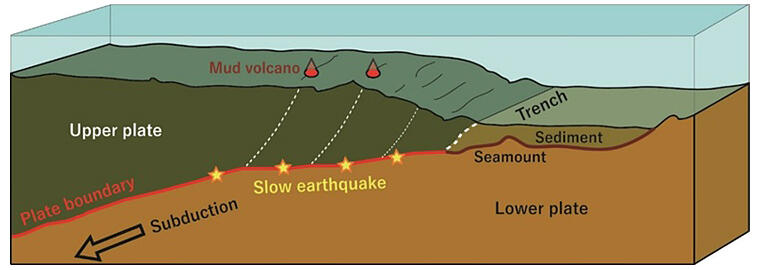
A research group led by Researcher Ryuta Arai of the Research Institute for Marine Geodynamics (IMG) at the Japan Agency for Marine-Earth Science and Technology (JAMSTEC), in collaboration with the Atmosphere and Ocean Research Institute and Earthquake Research Institute (AORI) at the University of Tokyo, the Faculty of Science and Technology at Kochi University, and others, announced their discovery of multiple low-velocity columns of several kilometers (km) in width in the upper plate that extends vertically from the sea floor at the westernmost point of the Nankai Trough in the Hyuga-nada area to the plate boundary (10−13 km in depth). The columns were revealed by analyzing seismic wave data obtained from seismic refraction and reflection surveys. The findings are expected to lead to the clarification of the mechanisms underlying both megathrust and slow earthquakes. The results were published in the British scientific journal Nature Communications on September 20, 2023.

Provided by JAMSTEC
Several plate boundary earthquakes of magnitude 7 have occurred in the Hyuga-nada area in the past, and recent ocean bottom seismic observations indicate that slow earthquakes, such as low-frequency microtremors and very low-frequency earthquakes, are occurring in areas shallower than the epicenter of these large earthquakes. The Kyushu-Palau Ridge subducts into these areas from the southeast. Researchers had speculated that the subduction of seamounts with large undulations on the seafloor is related to seismic activity, but the details were unknown. Additionally, many mud volcanoes are distributed on the seafloor of the Hyuga-nada area, but the origin of the fluids involved in forming these volcanoes was unknown. Therefore, the research group conducted a seismic wave survey aboard the seafloor wide-area research vessel 'KAIMEI' in August and September 2020.
For the survey, 50 seabed seismometers were installed at 2 km intervals along the survey line. An air gun towed near the sea surface was used to emit acoustic waves into the sea, and the acoustic waves and seismic waves refracted from beneath the seafloor were then recorded. The P-wave velocity beneath the seafloor was estimated from the travel time of the P-waves (initial motion) that reached the seabed seismometer earliest among recorded seismic waves and from waveform information, including subsequent waves. Additionally, a seismic reflection survey was conducted along the same survey line to investigate the geological structure beneath the seafloor. A receiver was used to capture and analyze the air gun-emitted acoustic waves, which were reflected at a boundary surface beneath the seafloor where the velocity and density varied and returned near the sea surface again.
As a result of analyzing the acquired data, the researchers discovered multiple low-velocity columns of several kilometers in width within the upper plate that extend vertically from the sea floor surface to the plate boundary.
The area containing these low-velocity columns appeared to be a fracture zone caused by the subduction of the Kyushu-Palau Ridge and was found to be connected to a fluid-rich region where slow earthquakes occur.
Around the fracture zone, several steep topographical features and circular sea hills that continued along the line were observed. In particular, it became clear that some of the circular sea hills may have formed mud volcanoes on the seafloor surface. The fracture zones found are speculated to be the pathways for upwelling fluids from the plate boundary, and some of them have mud volcanoes on the seafloor surface where fluids exit.
Although the exact depth of slow earthquakes in the Hyuga-nada area is unknown, the findings from this study indicate that fluid distribution and slow earthquakes are closely related. Future analysis with the addition of seismic survey data from the surrounding area is expected to enhance current knowledge about fluid circulation in plate subduction zones and the mechanisms underlying megathrust and slow earthquakes. Such studies will contribute to disaster prevention measures to mitigate the damage caused by earthquakes and tsunamis that occur in the sea area.
Arai said, "The results of this analysis showed a much more complex underground structure than we expected. To be honest, I was very surprised to find features that have not been reported in other plate subduction zones. In the future, by utilizing data from a wider area, we would like to investigate in detail how the characteristics of the locations where earthquakes occur change from the Hyuga-nada area to the Nankai Trough."
Journal Information
Publication: Nature Communications
Title: Upper-plate conduits linked to plate boundary that hosts slow earthquakes
DOI: 10.1038/s41467-023-40762-4
This article has been translated by JST with permission from The Science News Ltd. (https://sci-news.co.jp/). Unauthorized reproduction of the article and photographs is prohibited.


