Associate Professor Takeshi Osawa of the Graduate School of Urban Environmental Sciences at the Tokyo Metropolitan University conducted an analysis of municipalities across Japan and found that agricultural lands located in the vicinity of river confluences may play a significant role in flood suppression. The results were published on November 18 in Environmental and Sustainability Indicators, a journal published by Elsevier. The research was supported by the Environment Research and Technology Development Fund and a grant from the Watershed Ecology Research Group.

Takeshi Osawa TMU, Agricultural land around river confluences could strongly suppress floods occurrences, Environmental and Sustainability Indicators, Volume 24, 2024, 100533, ISSN 2665-9727, https://doi.org/10.1016/j.indic.2024.100533. CC BY 4.0
It is known that natural environments are often well preserved in areas around river confluences. Proactive conservation of agricultural lands in these locations may help to achieve disaster prevention and biodiversity conservation. Osawa expects that the research results will provide important guidelines for land use planning for flood resistance in human habitats as well as the maintenance of the natural environment.
Due in part to climate change, large-scale natural disasters such as typhoons, torrential rains, and associated floods and landslides are increasing worldwide. It has been pointed out that man-made structures such as dams and levees alone are not sufficient to cope with these increasingly severe natural disasters. In response to this situation, the concept of Ecosystem-based Disaster Risk Reduction (Eco-DRR), which utilizes existing ecosystems such as agricultural lands and urban green spaces, is attracting attention. In addition to disaster prevention and mitigation functions, Eco-DRR is expected to bring various benefits to the human society, such as biodiversity conservation.
One way to achieve this is to utilize agricultural lands that exist throughout the country. The inherent role of agricultural lands is food production. However, they are also thought to contribute to disaster prevention and mitigation through the storage and infiltration of rainwater as well as the temporary containment of floodwater. Empirical studies on this topic are being undertaken.
In his previous research, Osawa showed that agricultural lands under topographical conditions that make it easy for water flowing on the surface to accumulate effectively prevent the occurrence of flood disasters, regardless of whether the lands are used as paddy fields or dry farmlands. However, it is not easy to maintain a large agricultural land in Japan, where available land is limited due to steep terrains. In addition, there are cases where agricultural lands are abandoned and converted into urban areas.
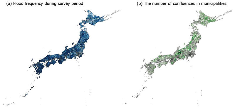
Identifying agricultural lands where disaster prevention is highly effective, and other benefits can be expected and taking measures to prioritize their preservation is expected to lead to more efficient and beneficial land use. Therefore, Osawa conducted a study with the aim of identifying indicators for finding farmlands with high disaster-prevention effectiveness. He focused on the topographical condition of confluence as an indicator, which is always present in natural rivers. The hypothesis that agricultural lands that can easily store water in the vicinity of river confluences may effectively control the occurrence of floods was established and tested on a broad scale using statistical information and other methods. A statistical model was used to examine the relationship between flood frequency and agricultural land around river confluences in 1,917 cities, towns, and villages across the country.
First, Osawa used data from the "Statistical Survey on Flood Damage"—a statistical survey conducted by the Ministry of Land, Infrastructure, Transport and Tourism (MLIT)—to determine the number of floods that occurred in each of the 1,917 cities, towns, and villages in Japan during 2010-2018.
Next, he used a statistical model to examine the relationship between the total area of agricultural land located in areas within a city, town, or village that are prone to water accumulation and the frequency of flooding. Consistent with previous research, the model showed that cities, towns, or villages with agricultural lands that met these conditions experienced a low frequency of floods.
Following this, using GIS data on river lines published by the MLIT, Osawa selected river confluence points across Japan and calculated the total area of agricultural land located within 1 km of river confluences that are thought to be prone to floods for each city, town, and village. The relationship between this area and the frequency of floods was examined using a statistical model. This examination yielded the same results as those of the examination of the aforementioned model - that is, flooding was less frequent in municipalities with agricultural lands where water tended to accumulate around the confluences. This effect was shown to be stronger than when using the entire agricultural land prone to flooding.
Journal Information
Publication: Environmental and Sustainability Indicators
Title: Agricultural land around river confluences could strongly suppress floods occurrences
DOI: 10.1016/j.indic.2024.100533
This article has been translated by JST with permission from The Science News Ltd. (https://sci-news.co.jp/). Unauthorized reproduction of the article and photographs is prohibited.


