
Activities of Nuclear Waste Management Organization of Japan (NUMO)
Expected to take two years prior to borehole investigation
The results will be provided to local residents, and organizes dialogue opportunities.
High-level radioactive waste must be isolated from the human environment until its radioactivity is sufficiently reduced. Many different ways of doing this have been considered in countries around the world, and, as a result, geological disposal is thought to be the safest method and the research and development to accomplish this is ongoing.
To implement geological disposal, social interests need to be increased and a deeper understanding of the mechanisms of geological disposal and Japan's geological environment are required. To achieve this, in July 2017 the government (the Agency for Natural Resources and Energy) published its Nationwide Map of Scientific Features relevant for Geological Disposal, and the government and the Nuclear Waste Management Organization of Japan (NUMO), which leads the geological disposal project, made use of this opportunity to carry out public relations and opinion exchange activities to increase people's understanding of geological disposal.
In October 2020, Suttu town in Hokkaido applied for literature survey, and Kamoenai village accepted a proposal from the government for literature survey. In response to these acceptances, NUMO began literature surveys--the very first literature surveys of the selection process for a disposal site--in both municipalities in November the same year.
The Science News focused on these literature surveys, delving into the details.
Nationwide Map of Scientific Features relevant for Geological Disposal
When selecting a site for geological disposal, what scientific features do we need to consider? How are these distributed across Japan? The Nationwide Map of Scientific Features relevant for Geological Disposal indicates these on a map of Japan in a way that is easy to understand.
When creating the Map, studies by experts that explored what kind of requirements and standards could be assigned were carried out by the Geological Disposal Technology Working Group under the Nuclear Energy Subcommittee of the Electricity and Gas Industry Committee, which is part of the Advisory Committee for Natural Resources and Energy.
Literature Survey
What is a literature survey?
A disposal site will not be decided using the Nationwide Map of Scientific Features relevant for Geological Disposal. NUMO will carry out site investigation to select a disposal site based on the Designated Radioactive Waste Final Disposal Act (Final Disposal Act). The site investigation will be carried out through three processes: (1) a literature survey (an assessment using literature, such as the history of past earthquakes, etc., active faults, and volcanoes: approx. two years), (2) a preliminary investigation (an assessment that gains an understanding of underground rock, and the properties and state of groundwater through a borehole investigation, etc.: approx. four years), and (3) a detailed investigation (a detailed assessment through investigation in underground facilities: approx. 14 years)
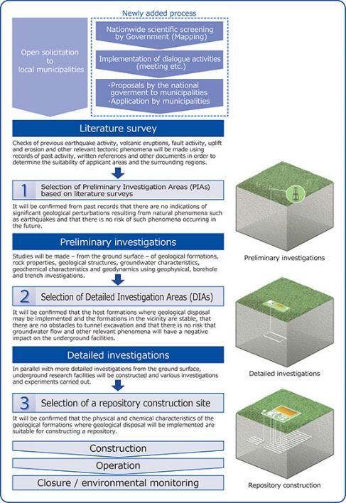
The first to be carried out will be (1) a literature survey. This survey does not involve any on-site activities such as borehole investigation; it is desk research carried out based on literature and data, such as geological maps and academic papers. Furthermore, during the period in which the literature survey is being implemented, information of the site characterization will be provided to the local people, with the aim of ensuring an in-depth understanding of the geological disposal project among municipalities. It is stipulated in law that NUMO will carefully listen to local opinion when deciding whether to continue with the next step, (2) a preliminary investigation, and if there is opposition then this will not go ahead.
Aim
The aim of the literature survey is to understand the conditions of underground as far as it is known from literature and data related to the area that is the focus of the survey, so as to consider the final disposal of radioactive waste. In terms of requirements to be assessed for the literature survey, NUMO is requested that: ◇There are no dramatic geological changes (volcanic/igneous activity, active faults, uplift/erosion, etc.), and ◇When carrying out geological disposal there are no mineral resources or unconsolidated sediment that has insufficient strength as bedrock, which would make constructing underground facilities difficult.
NUMO will collect literature and data about these points, and make an assessment. Based on the outcome, locations that clearly have low suitability will be excluded.
Implementation process
There are two ways that a literature survey can take place: (1) If a municipality applies to NUMO, or (2) If a municipality is asked to accept a proposal for the survey from the government. For example, (1) is the case of Suttu town, and (2) is the case of Kamoenai village. In the case of (1), first of all, the Nationwide Map of Scientific Features relevant for Geological Disposal will be used to check whether it might be possible to find a suitable site for geological disposal, and to confirm any expectations of carrying out a investigation. After the process of (1) and (2) , literature and data will be gathered for the survey, and the obtained information will be organized. Using the information, assessment will be carried out to check whether there are geological movements and mineral resources. The results will be summarized in a report.
Requirements for Assessment based on literature and data
Requirements for Assessment of the literature survey (examples of information to be used for the assessment) are the following;
- No records of significant geological change caused by natural phenomena such as earthquakes. Predictions that there is low risk of the occurrence of significant change in geological conditions caused by natural phenomena such as earthquakes in the future. ◇Volcanic and igneous activity, etc. (▽presence of quaternary volcanoes or craters, ▽distribution of volcanic ejectors and intrusive rock, age, ground temperatures around volcanoes, the acidity of groundwater, etc.) ◇Fault activity (▽presence of active faults and its characteristics, ▽width, deformation, and location of fault crush zones, ▽presence, deformation, and location of active folds and active flexures ). ◇Uplift/erosion (▽distribution and age of terrace surfaces, ▽the scale of erosion)
- No records relating to the presence of mineral resources with high economic value (▽type, distribution, scale, and quality of mineral resources, ▽information relating to rights)
- No records indicating that the geological formation where final disposal would be implemented are unconsolidated sediment (distribution and characteristics of unconsolidated sediment).
Interview of Hideaki Hyodo, Director of the Science and Technology Department, NUMO - Avoiding locations with strong crustal movement and places that humans may dig up. Considering the flow of water and redox conditions -
We interviewed Hideaki Hyodo, Director of NUMO's Science and Technology Department, and asked him about the details of the literature survey.
What is the relative significance of the literature survey?
In terms of the selection process for a disposal site, we will proceed in stages based on the Final Disposal Act, carrying out literature survey (a desk-top study), preliminary investigation (borehole investigation, geophysical investigation, etc.), and detailed investigation (investigations and tests in underground facilities), to determine a final disposal site.
The Nationwide Map of Scientific Features relevant for Geological Disposal was published by the government in July 2017, and displayed favorable and unfavorable features for geological disposal. Fundamentally, it shows to evaluate the nationwide geological conditions in an impartial manner. In contrast, the literature survey does not cover the entire country; there are varieties of research papers and written survey reports about each area. The literature survey is to assess the geological conditions based on these papers and reports and to summarize it in a report that considers whether we can take the next step.
Can you tell us about the specific content of the literature survey?
We will avoid locations in which there is significant movement caused by volcanoes and active faults. On top of this, once a period of at least 100,000 years has passed, geological formation will rise, little by little (uplift), depending on the location. The raised parts will wear away due to rain and rivers, etc.--even a location deeper than 300 meters will rise and approach the surface (erosion). Therefore, we will also preemptively avoid locations in which there is severe uplift and erosion. In addition, we will avoid places that humans might dig up in the future, and places with unconsolidated sediment.
What kind of locations are likely to be dug up in the future?
Locations that are close to sites where waste has been disposed of and that have coal, oil, or metal resources. In the future, if people don't know that there is waste buried in an area, there is a risk that they will dig it up to surface and collect such mineral resources and come into contact with the waste, so we must prevent this from happening.
What is unconsolidated sediment?
This is loose rock in which the accumulated sand and mud, etc. have not solidified. We cannot dig tunnels to bury waste in such locations. In the stage of thorough investigation, we will carry out borehole investigation, etc. and perform strength tests on extracted rocks during the stage when we carry out a thorough investigation, But in the literature survey stage, if an area has geological formation that are clearly weak, we will preemptively avoid the area because it is impossible to excavate.
You'll be considering these requirements as you investigate a variety of aspects during the literature survey. How will you proceed?
After receiving applications from local municipalities, NUMO will publish a plan for a literature survey, as well as offer explanations to the local populace, and then begin the survey.
Right now, we have just started gathering literature and organizing the information we have obtained. We will carry out an assessment by applying the assessment requirements to these, summarizing this into a report, and, as appropriate, bring this information together to explain it to the local people. If there are suitable places in Suttu town and Kamoenai village that meet the necessary requirements, we will prepare proposals indicating that we wish to select these as candidates for the implementation of the next stage, a preliminary investigation, and send an application to the Minister of Economy, Trade and Industry. Of course, we will need permission from the government, but to progress to that next step, we also require that there is no opposition from the prefectural governor and the head of the local municipal government.
How long will it take to carry out the literature survey?
We won't know until we actually try, but as an estimate, we predict it will take about two years.
By the way, I thought that organizations such as the Geological Survey of Japan have an understanding of the geology across Japan?
It's true that they understand this on a national level, but even so there are areas that they are unable to explore. We will carry out our own survey that incorporates literature and data containing information about representative faults and geological maps and investigate these once again.
I believe geological maps only show the state of the ground surface--how will you investigate areas deep underground?
Geological maps are basically made by walking over the ground surface and observing the geological formation that are exposed on cliffs and other features. There are sometimes cross-section diagrams that estimate what the area below ground looks like from the trends in these geological formations, and so even during the literature survey we can get a general understanding of the geology deep underground. We will investigate through borehole investigation, etc. from the preliminary investigation onwards to gain more details.
Traces of extreme events such as volcanoes or active faults remain on the ground surface, making their presence easy to comprehend during the literature survey. Therefore, we will first exclude these places as inappropriate locations for geological disposal as we carry out the survey; next, we will carry out on-site investigations such as borehole investigation and survey in more detail of deep underground.
You mentioned that it is important to understand water flow and oxygen-free conditions (redox conditions) in deep underground--could you tell us a bit more about this?
It's true that considering parameters such as water flow and redox conditions is important. Water flow is generally slow in deep areas, but has a tendency to become faster when there is a large elevation difference on the ground surface. Moreover, how easily water passes through each bedrock also varies. It is difficult to grasp how easily the water passes through the bedrock using literature, so we will gain an understanding of this via on-site investigations such as borehole investigation. In addition, redox conditions make it hard for things to dissolve in water--even if we bury radioactive waste, any radioactive substances will not easily dissolve, making these conditions convenient.
Finally, people believe that detailed investigations of areas deep underground haven't really been carried out to date. For this reason, we can anticipate that carrying out such investigations and obtaining results will yield important materials for Japanese geology in the future, right?
I think that there'll be a lot of that. Generally, boring and geophysical exploration are costly and can't be done easily, so there are few examples. I believe that this will be significant in terms of the data and materials used to investigate the geology deep underground in detail.
Basic knowledge of high-level radioactive waste The long-term isolation of radioactive materials from human environments using a multi-barrier system At the end of lengthy discussions: "The safest method"
What is high-level radioactive waste?
In Japan, the fuel used in nuclear power plants is reprocessed and obtain uranium and plutonium that can be used as resources. The high-level radioactive waste liquid produced during this process that is vitrified becomes high-level radioactive waste (vitrified waste). At the moment, approximately 19,000 tons of spent nuclear fuel is stored in nuclear power plants and other locations, and once this is reprocessed in the future, combined with already reprocessed materials, it will come to the equivalent of around 26,000 vitrified wastes.
The disposal of high-level radioactive waste is an issue for our generation, which until now has used nuclear power as a form of economic and stable energy. The people of Japan must have an interest and pave the way for its final disposal by holding discussions so that the responsibility is not pushed onto the next generation.
About geological disposal
The issue of the disposal of high-level radioactive waste is not unique to Japan. It is the issue shared among all of the countries that use nuclear energy (in countries that have not chosen to carry out reprocessing, spent nuclear fuel is high-level radioactive waste).
Long international discussions yielded a shared fundamental approach: that geological disposal is the optimum method for final disposal. The key points of this approach shared by different countries include, firstly, that high-level radioactive waste requires an extremely long period for its radioactivity to be reduced, and so it is difficult for humans to continue to manage it. We must carefully pave the way towards a solution for which the current generation will take responsibility, so we do not leave this burden to future generations.
To accomplish this, it is vital that we adequately isolate high-level radioactive waste from environments in which humans live for a long period of time. "Geological disposal," in which the waste is buried in stable bedrock over 300 meters underground, is considered to be the safest method for this isolation.
The geological disposal method
Geological disposal, in which the waste is buried in deep underground stable geological formation, is a multi-barrier system that combines "engineered barriers" and "natural barriers," and a method that isolates radioactive materials from environments in which humans live for a long period of time, controls their movement, and contains them.
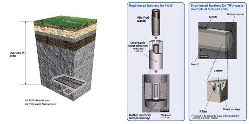
The engineered barriers will consist of vitrified waste, an overpack, and a buffering material (compacted clay). Vitrified waste is made up of radioactive materials contained inside glass matrix, which will not easily dissolve into groundwater for a long time; it will have a diameter of 40 centimeters, and a height of approximately 1.3 meters. The overpack will be a metal container around 20 centimeters thick in which the vitrified waste will be encapsulated, with the role of preventing groundwater from coming into contact with the vitrified waste while it is highly radioactive. Moreover, the overpack will be covered in a buffering material around 70 centimeters thick, which will retard the movement of groundwater and radioactive materials.
Meanwhile, the natural barriers will be the bedrock in deep underground. There is very little oxygen in deep underground, making it hard for corrosion to occur. Furthermore, the movement of groundwater is extremely slow, so even if radioactive material does leak out into the groundwater, its movement will be retarded even more as it will seep into the bedrock and be absorbed.
Previous initiatives towards final disposal
The Designated Radioactive Waste Final Disposal Act (Final Disposal Act) was enacted in May 2000 to systematically and practically carry out final disposal of high-level radioactive waste, etc. Based on this act, the three-stage investigation process to select a disposal site was set up, and NUMO, which leads disposal, was established.
In 2002, NUMO began open solicitation from municipal governments to host investigations, but it did not reach the stage of implementing a literature survey for a long time. The Inter-Ministerial Council for the Final Disposal of High-Level Radioactive Waste was set up in December 2013 to break the deadlock, and launched a radical review of the initiatives to date. In May 2015, a cabinet decision was made on a new fundamental policy based on the Final Disposal Act. Within this, it was made clear that the government would take the lead in initiatives so as to gain the understanding and cooperation of citizens and local people in the regions. Moreover, the Nationwide Map of Scientific Features relevant for Geological Disposal was published in 2017, which displayed scientific features for local areas relevant to geological disposal and these in an easily comprehensible manner by color coding a map of the entire country.
Glossary
- Quaternary: The geological period from approximately 2.6 million years ago to the present day.
- Intrusive rock: Rock that formed when underground magma cooled and hardened underground without reaching the surface. It is classified based on shape and structure; terms such as "dike" and "sill" are sometimes used.
- Active fold, active flexure : A fold occurs when layered geological formation deform into a wave-like structure due to horizontal pressure exerted on them. A lithospheric flexure is formed in areas where rock layers are thickly deposited: the deep base moves up and down due to fault movement, causing the rock layers to bend with the layers still connected without a fault appearing near the surface. Active folds and active lithospheric flexures are either currently active or have recently been active, and may be active again in the future.
- Terrace: Topography adjacent to a river, sea, lake, etc. that is arranged in steps, with flat surfaces and steep escarpments. How much the land rose in the past and the time required for this can be estimated from the elevation of the terrace surfaces and when they were formed.
- Unconsolidated sediment: Accumulated material such as gravel, sand, and mud that is not consolidated.
This article has been translated by JST with permission from The Science News Ltd.(https://sci-news.co.jp/). Unauthorized reproduction of the article and photographs is prohibited.