Since its establishment immediately after the torrential rainfall disaster of July 2018, Hiroshima University's Resilience Research Center has carried out interdisciplinary research using "Synergistic Torrential Disaster" as an overall theme. This article addresses the field of traffic management. From the experience gained from torrential rain disasters, the following measures are introduced: creation of a risk map for early restoration of traffic function, observation of traffic congestion in the restoration of roads, sharing of comprehensive traffic information, determination of road restoration priority, support for evacuation of steep-slope residential areas using green slow mobility, and development of new disaster prevention measures in the digital era, such as evacuation in the case of a torrential rain disaster under pandemic conditions.
Creating a risk map to restore traffic function early
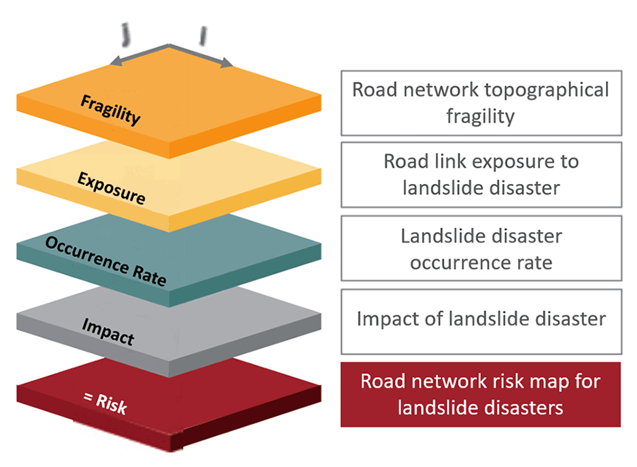
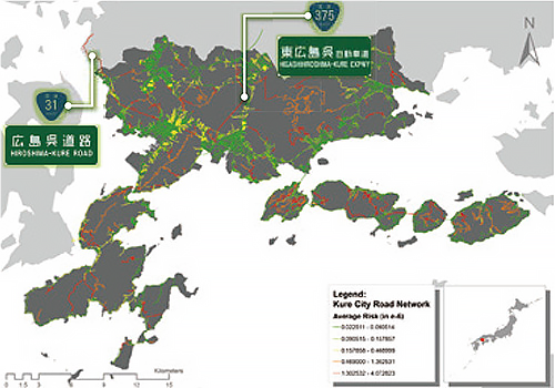
During the torrential rain disaster of July 2018, a large-scale traffic network was disrupted over a wide area around Hiroshima City, Kure City, and Higashi-Hiroshima City, causing tremendous damage not only to lifesaving efforts and transportation of emergency relief supplies but also to residents' daily lives and economic activities. To maintain the functionality of roadway networks during large-scale torrential rainfall disasters, a comprehensive roadway network risk assessment is required, with spatial risk maps superimposed on topological vulnerabilities, exposure, hazards, and disruption probability, etc. In response to this, a framework was constructed for the risk assessment of road networks (Fig. 1) and a spatial risk map was produced for Kure City (Fig. 2).
Observing traffic congestion during roadway recovery
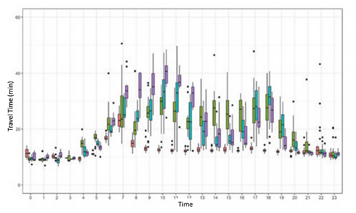
After a disaster, road capacity and traffic demand changes from moment to moment in response to road recovery. To understand these dynamic traffic conditions, it is important to use traffic observation equipment on roadsides as well as passive data that continuously record communication history and automobile movement trajectories. Multiple traffic count data from the prefectural police, ETS2.0 data of the Ministry of Land and Transport, mobile space statistics retrieved from Docomo mobile phones, and commercial vehicle probe data of Fujitsu were successfully synchronized to obtain temporal changes in link travel time (Fig. 3) and traffic-time occupancy diagrams (Fig. 4) in real time.

Sharing comprehensive traffic information
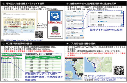
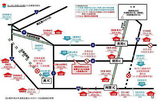
During the torrential rain disaster of July 2018, roadway congestion exceeded expectations, and there were sections of road between Hiroshima and Kure where the time required to travel was more than three times higher than normal. To resolve this congestion, a movement from motor vehicle to public transport was required, and a disaster BRT (Bus Rapid Transit) was operated by special measures using a part of the highway area (Photo 1). In addition to this, volunteers gathered to inform users and set up a regional public traffic information portal to provide real-time information on public traffic during disasters (Fig. 5).

Determining road restoration priority
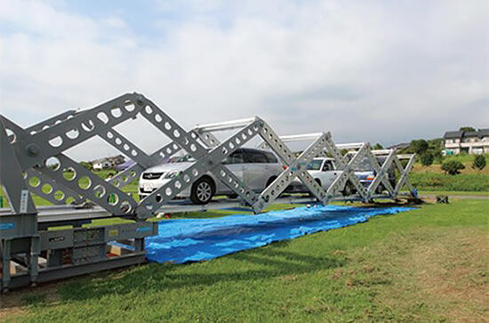
During the torrential rain disaster of July 2018, the road network of the entire urban area was affected, with disruptions and decreased capacity occurring simultaneously along many road sections. For the most efficient recovery of the functions of a road network and restoration of affected roadside areas when resources are limited, it is important to determine the order of restoration for the roadside area, such as the establishment of the first aid temporary "mobile bridge" (Photo 2) and restoration work. Simulations were performed to determine the optimal restoration order (Fig. 6).
Supporting evacuation in steep-slope residential areas using green slow mobility
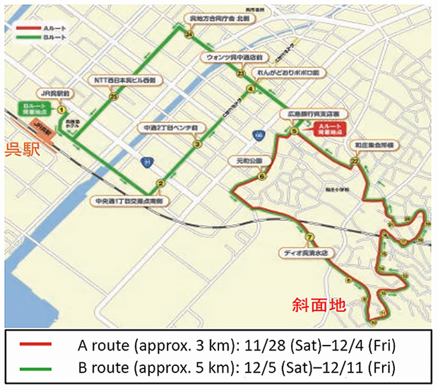
In Kure City, with its extensive sloped areas, elderly persons faced many barriers to evacuation during the torrential rain disaster. In particular, it was difficult to evacuate from steep-sloped residential areas with narrow roadsides, both by car and on foot, even when evacuation orders and other information reached residents. Therefore, a demonstration study was conducted of the introduction of "green slow mobility" (Photo 3) to support walking access to bus stops several hundred meters or further away. During a two-week period in November 2020, it was confirmed that users and non-users urgently needed a means of evacuation and mobility, as a route connecting Kure Station, the central commercial streets, and the steep-slope residential streets was operated according to a regular schedule (Fig. 7).

Evacuation during a torrential rain disaster under pandemic conditions
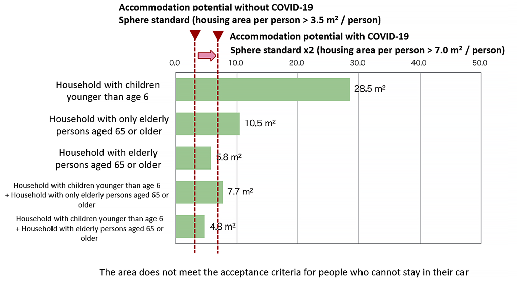
If a torrential rain disaster occurs during the COVID-19 pandemic, it is necessary to establish a standard for avoiding the risk of infectious diseases (sphere standard) and to optimize the placement of evacuation facilities to reduce the risk of natural disasters within that range. The access distance to the nearest evacuation facility and the access time are about 1,300 m and 23 minutes in the Hachihonmatsu-nishi District of Higashi-Hiroshima City (Fig. 8). By applying a density avoidance acceptance criteria for evacuation facilities, it was confirmed that households with older adults age 65 or older (many of whom do not possess a car and are unable to evacuate separately, such as by staying in their car overnight) did not meet the criteria, and that a review of the plan to accommodate evacuated residents after avoiding the risk of infectious diseases is necessary (Fig. 9).


Akimasa Fujiwara
Resilience Research Center, Hiroshima University