
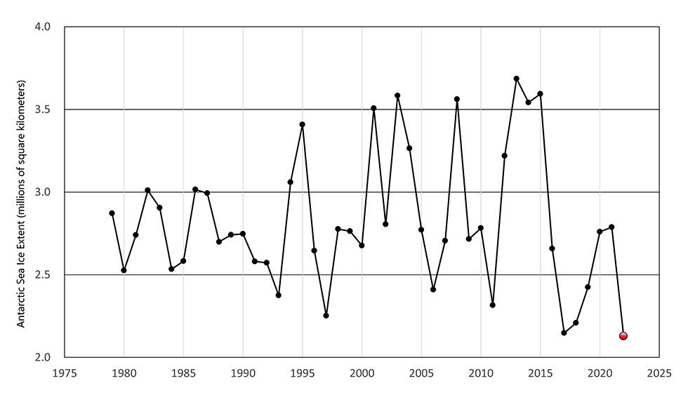
The National Institute of Polar Research (NIPR) has announced that a new record was set for the minimum observed area of Antarctic sea ice in February at 21.28M square kilometers. This is slightly lower than the previous record observed in March 2017 of roughly 21.5M square kilometers. A system is currently being organized for gathering undersea data, which is essential for predicting future increases and decreases in sea ice, raising expectations among experts.
Sea ice is sea water that has frozen and become ice. The distribution of this ice is inconsistent, with some areas of sea water featuring a concentration of thick ice, and only thin and sparse ice being found in other areas. Accordingly, NIPR defines sea ice surface area as any area where the concentration of sea ice (the ratio of the sea surface covered by ice) on the surface is 15% or greater.
A research team comprised of members from NIPR and the Japan Aerospace Exploration Agency (JAXA) has been observing the surface area of sea ice in the Arctic and Antarctic regions using satellites since 1978. The team is currently using data provided by the Global Change Observation Mission satellite SHIZUKU (GCOM-W), launched in 2012, to analyze the changes in the ice in terms of both space and time.
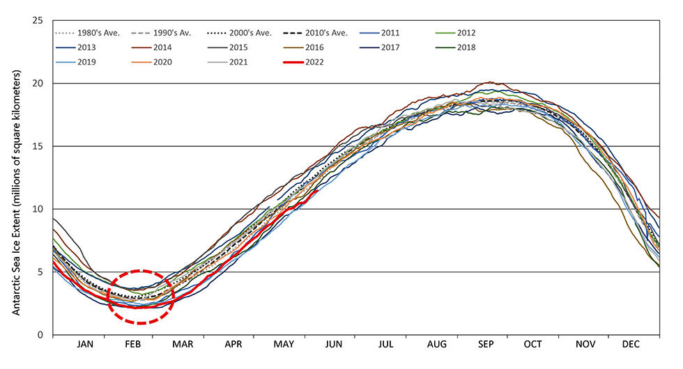
During the 2021-2022 season, the extent of Antarctic sea ice showed a gradual decline beginning around October 2021, reaching roughly the third smallest extent on record since the 2000s. This decline continued in the new year, and a new record was set for minimum extent on February 20, which marks the height of the Antarctic summer.
(Provided by the National Institute of Polar Research and JAXA)
(Provided by the National Institute of Polar Research and JAXA)
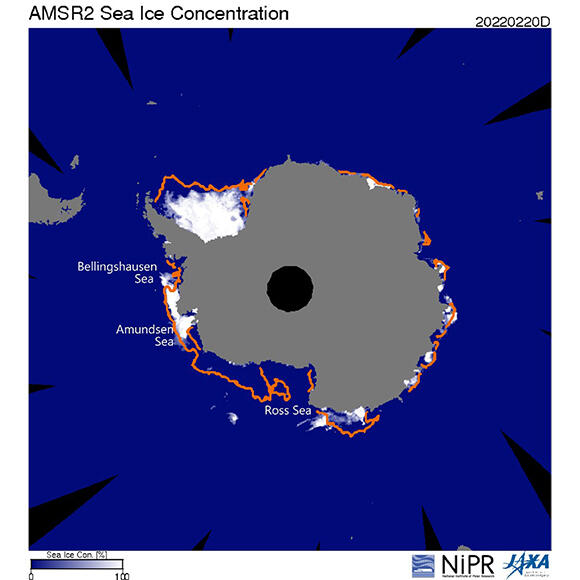
The average minimum sea ice area per year over the last 10 years (2012 to 2022) is 29.02M square kilometers, with the new record set this year representing only about 73.3% of the average. Broken down by region within the Antarctic Ocean, there was a significant decline in sea ice along the coast on the Ross Sea in 2022, similar to 2017.
(Provided by the National Institute of Polar Research and JAXA)
Is this decline in Antarctic sea ice caused by global warming? We asked Professor Hiroyuki Enomoto, Vice Director-General of NIPR. According to Professor Enomoto, "Compared to the decline in sea ice surface area in the Arctic, we cannot say that the decline in the Antarctic is caused only by climate change, and for that reason, researchers are analyzing the situation in earnest as we speak."
He adds, "We can clearly say that for the past 30 years, sea ice surface area in the Arctic has been declining along with the progression of global warming, and the UN's Intergovernmental Panel on Climate Change (IPCC) has reported that 'it is highly likely that sea ice will disappear in the year 2050.' In contrast, the surface area of sea ice in the Antarctic was actually rising up until 2014, in spite of the effects of global warming but began to fall rapidly after that year. Even the IPCC has not yet reached a conclusion on whether this rapid decline is a long-term trend."
In Antarctica, the surface of sea ice that appears along the coasts of the continent in the wintertime rivals the size of the continent itself, and in years where there is more sea ice during the winter, there is more in the summer as well.
The extent of sea ice is also influenced by the weather. Summer storms, for example, reduce the sea ice by blowing a portion of it against the continent. Meanwhile, higher temperatures cause the continental ice sheet to melt, causing water to flow into the ocean and making it more difficult for ice to form in those regions of the ocean. Therefore, the areas in which sea ice declines can differ from year to year.
According to Professor Enomoto, "In the case of Antarctica, we have to consider the interaction between the atmosphere, the ocean, and the ice sheet. The impact of global warming on Antarctica was long expected to appear later than other areas, but this current decline in sea ice surface area may be a sign of that impact."
We asked Professor Enomoto what breakthroughs would be required to investigate the causes of the decline.
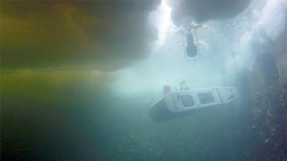
Professor Enomoto commented, "Before we increase the spacial resolution of the satellite images or increase the performance of the computer used for analysis, we need observational data gained from a multifaceted approach. The GCOM-W satellite monitors changes in sea ice from above, so it is important for more observational data from under the sea. We expect to collect data from floats that can float among the ice, mooring systems on the seafloor, and AUVs (Autonomous Underwater Vehicles)."
Underwater observation in the oceans around Antarctica is a field of fierce competition between Japan, the United Kingdom, Germany, Norway, and other countries. A research group from NIPR led by Professor Yoshifumi Nogi succeeded in fully automated observation of the underside of sea ice in March 2021 using the MONACA AUV, co-developed with Associate Professor Toshihiro Maki and others of the Center for Integrated Underwater Observation Technology, Institute of Industrial Science, the University of Tokyo, and the AUV will be applied to undersea observation in the Antarctic Ocean before the end of this year.
(Provided by the University of Tokyo and NIPR)
MONACA is capable of submerging below sea ice and ice shelves to observe the shape of the underside of the ice at high precision, while operating fully autonomously. The AUV is capable of detecting and avoiding obstacles, hovering in place, and can submerge to a depth of up to 1,500 meters. Research on Antarctica sea ice will advance once image data from above and undersea observational data is obtained.
Professor Enomoto says emphatically, "It is possible today for anyone to access NIPR's Arctic Data archive System (ADS) and see the satellite imagery for yourself, even if you are not a specialist. I recommend that you do, because you will be able to understand the seasonal changes and changes over time in the sea ice surface in the Arctic and Antarctica. If you are interested, you can also see weather and oceanographic data, such as pressure patterns and wind speeds, allowing you to make your own predictions and consider the causes."
Phenomena such as the decline in sea ice surface area that are caused by temperature rises and climate change are often quickly attributed to global warming, but researchers are examining the data carefully and earnestly to confirm whether they can really be attributed to it, or if there are other causes as well. But by seeing the ever changing satellite imagery, we can learn for ourselves about the dynamism of earth observation and the difficulty of analyzing it.
AKANE Akari / Journalist
Original article was provided by the Science Portal and has been translated by Science Japan.