
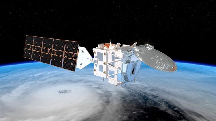
The observation satellite Hakuryu (EarthCARE), jointly developed by Japan and Europe to refine climate change prediction, was launched on May 29th. The four onboard observation instruments work together to reveal the state of cloud particles and dust particles in the atmosphere as well as the three-dimensional structure and mechanisms of clouds. Japan has developed a radar to study the detailed three-dimensional structure of clouds. As the world's first satellite-mounted spaceborne Doppler radar, it captures the vertical velocity of cloud particles and raindrops, and there are high expectations for the data it collects.
Provided by ESA and ATG Media Lab
The "divine beast who governs the waters" aims for the heavens
Hakuryu is 17.2-m long, with its solar panels and antennas extended in space, and weighed 2.3 tons at launch. It flies at an altitude of 400 km in a north−south orbit in 90 minutes per revolution, taking 25 days to cover the entire globe. The design life is 3 years. The satellite was loaded onto SpaceX's large "Falcon 9" rocket and launched from the Vandenberg Space Force Base in California on the 29th. The European Space Agency (ESA) will operate the satellite at a control facility in Germany. Observation data will be provided to researchers in Japan via the ESA facility in Italy and the Japan Aerospace Exploration Agency (JAXA).
The name EarthCARE is derived from a combination of the English word for earth, "Earth," and the initials of "Cloud Aerosol and Radiation Explorer," meaning that which examines clouds, particles (aerosols) and radiation. The name appears to be a play on the phrase "observation to care for the earth."
Hakuryu is the Japanese name announced by JAXA in April. The satellite's body is white, and the solar panels look like an elongated tail, making it resemble an imaginary "white dragon." JAXA said, "the dragon is considered a divine beast that controls water, which is appropriate for our goal of clarifying the mechanism of the atmosphere. The white dragon can fly fast and fits the image of a satellite orbiting at a high speed."
Understanding the three-dimensional structure of clouds is a challenge
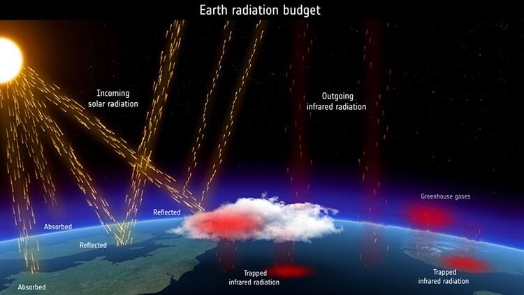
Climate change predictions are made through computer simulations and other methods, but mankind does not fully understand the relevant phenomena, and this entails uncertainty. A major factor in this is the effect of clouds and particulates. Clouds have the effect of absorbing heat from the earth's surface and returning some of it to warm the surface, as well as reflecting sunlight. This energy balance, or "radiation budget," determines the atmospheric temperature. It involves the thickness and height of clouds, the size and shape of cloud particles and the amount of moisture. The presence of fine particles also greatly affects the properties of clouds, influencing the degree of sunlight reflection and absorption.
Provided by ESA and ATG Media Lab
However, it has been difficult until now to observe cloud particles and fine particles with high precision, and the mechanisms of phenomena occurring in clouds have not been fully clarified. Weather satellites such as Himawari can only observe the tops of clouds and cannot grasp the three-dimensional structure of their interior. Moreover, ground-based observations cannot observe the entire global cloud cover. Therefore, Hakuryu observes clouds and particulates on a global scale. In particular, information on the vertical movement of clouds and fine particles will be accumulated, leading to a better understanding of their impact on climate.
The Sixth Assessment Report released by the Intergovernmental Panel on Climate Change in 2021−22 presented several scenarios, including a global average temperature increase of 2.8℃−4.6℃ between 2081 and 2100 compared to 1850−1900, assuming high greenhouse-gas emissions. It also stated that as temperatures rise, precipitation on land will increase, sea ice in the Arctic will decrease, sea level will rise and so on. A limitation in these projections is the large errors among climate models.
Linking simulation and observation data
Among the climate change factors, predictions on carbon dioxide (CO2), methane (CH4) and other greenhouse gases have a small margin of error. In contrast, fine particles and the interaction between fine particles and clouds remain subject to large errors because their detailed effects are not yet understood. The purpose of this project is to clarify these questions through the observations of Hakuryu and to improve the quality of predictions.
It is also important to link observation data with numerical simulation models using supercomputers to predict climate change and weather. Professor Masaki Satoh, whos studies Atmospheric Science and Meteorology at the University of Tokyo's Atmosphere and Ocean Research Institute, a member of the Hakuryu team, said, "Numerical modeling is a field in which Japan excels as we can take advantage of the world-class supercomputer Fugaku." There are very high expectations for this satellite because the rain and cloud representations by the model can be modified through observation data from it. It is useful for monitoring and simulating extreme phenomena such as torrential rains and typhoons."
He also said that by building the "Earth's digital twin" by linking observation data and numerical models, "A time will come when we can ask questions (related to weather and climate) and a generative AI (artificial intelligence) will answer them accurately."

Provided by RIKEN
First-ever "Doppler measurement" by satellite
While in orbit, Hakuryu will use four instruments simultaneously to make observations and combine data to produce results.
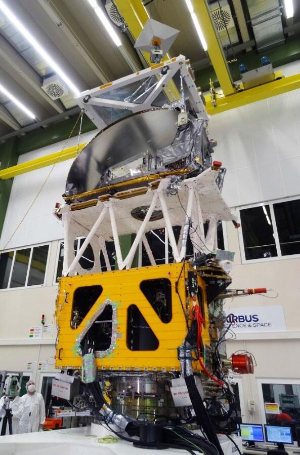
Of the equipment, Japan was responsible for the "Cloud Profiling Radar (CPR)," which observes cloud distribution and structure. The CPR was developed by JAXA and the National Institute of Information and Communications Technology (NICT). It was designed and manufactured by NEC. Radio waves are emitted from the CPR, which receives the radio waves bounce back when they hit clouds. The CPR in turn captures the size of cloud particles, the amount of moisture and the three-dimensional structure of clouds. For the first time ever on a satellite radar, "Doppler velocimetry" measures the rising and falling speed of cloud particles and raindrops to reveal their movement in the clouds.
In Doppler velocimetry, when a cloud or raindrop is moving away from a satellite travelling at 7 km/s − in other words, when it is falling - the frequency of the bounced radio wave is lower than the original radio wave. Conversely, the frequency is higher when it is rising or approaching the satellite. CPR precisely captures this and determines the "Doppler velocity" of cloud particles and raindrops. In particular, the upwelling in clouds is related to the formation of cloud particles, and CPR can greatly help in understanding the cloud formation process.
Although satellite radars have been used to observe clouds, they lacked the Doppler velocimetry function and could not capture vertical movement.

Provided by JAXA
Eiichi Tomita, Project Manager at JAXA, explains that the high sensitivity of CPR was achieved mainly through two innovations. One was to lower the satellite's orbit to an altitude of 400 km, bringing it closer to the earth's surface. The other was the development of a large antenna with a diameter of 2.5 m. "It is very difficult to measure the vertical velocity of clouds, which are only approximately 2−8-m across, from a satellite traveling at 7 km/s. If the antenna is misoriented even slightly, the satellite's velocity will be mixed into the measurement," he said. Therefore, they developed an antenna that is not easily deformed by heat. In addition, they have developed a transmitter that can produce repetitive pulses at a high speed. It uses radio waves with a wavelength of 3.2 mm, approximately one-tenth as short as a typical rainfall radar.
Deepening knowledge through Europe−Japan cooperation
The remaining three devices were developed in Europe. The "Atmospheric Lidar (ATLID)" observes small particles and thin clouds that CPR cannot cover. Radar, such as CPR, uses radio waves for observation, whereas lidar uses laser beams. In addition, it is equipped with a "multi-wavelength imager (MSI)" to observe the horizontal distribution of clouds and particulates, and a "broadband radiation balance (BBR)" to capture the radiation budget at the upper edge of the atmosphere.
ESA's project manager Dirk Bernaerts said, "We will begin observations three months after the satellite is placed in orbit, and will provide all the data to the world's scientific teams in six months. In particular, the Japanese and European teams will receive very high quality and interesting data and will deepen their knowledge."
Development costs related to the Hakuryu are 8.3 billion yen for JAXA, including CPR development and unique ground system maintenance costs, and undisclosed for NICT. For ESA, it is in the region of 800 million Euro (approximately 135 billion yen at the current exchange rate), including the launch cost. This is the first time that Japan and Europe have jointly developed an earth observation satellite.

Provided by ESA and ATG Media Lab
Like grabbing a cloud? The expectation of results
Development of CPR began in earnest in 2007. The launch was originally scheduled for 2013, but has been delayed repeatedly. Tomita recalls, "Japan and Europe each took on the challenge of developing difficult sensors. CPR had to be capable of measuring cloud speed from a satellite flying at a high speed. In addition to this, two transmitters were provided for a redundant configuration (with a spare in case of failure), but it took time to prepare the second one. It was difficult to develop high-power transmitters for Europe's lidar, and some time was required."
The onboard rocket has also undergone a series of changes. It was planned to be launched by the European company Arianespace from French Guiana in South America on a large Russian-developed Soyuz rocket. However, the company's Soyuz launches were halted due to Russia's invasion of Ukraine in February 2022. It was replaced by the company's new "Vega C," but was eventually replaced by Falcon 9 of the company's rival after its second launch failed. The world's growing shortage of rockets is having an impact here as well.
Sato said, "After 18 years of involvement in the project, this will be a long-awaited launch for me. It was a long time coming, but the timing is good, with numerical models becoming more sophisticated, and I am deeply moved."
The term "Grabbing at clouds" means that things are vague and elusive, but for Hakuryu it seems to be quite the opposite. The author cannot wait to see the "cloud-grabbing" vivid predictions of climate change that will result from this research that makes the most of detailed observations.
Provided by Airbus
(KUSAKA Takeo / Science Portal Editorial Office)
Original article was provided by the Science Portal and has been translated by Science Japan.